 |
| Reservoir in the Pittsfield Water Supply |
Unable to participate during the last two weeks, today was my first ride. It was a good one. I headed north to Sanger's General Store, hoping for samosas and coffee. They make extremely good samosas, but when I arrived, all were sold out. So I settled for a cup of adequate coffee and drank it at the picnic table outside before continuing north. The coffee did its job, and I headed north on Rt. 8A.
 |
| Pinarello at Sanger's General Store for a cup of coffee |
Rt. 8A is fun on a bike, mostly downhill and through pretty, protected wildlife management areas. In Savoy, I jogged east on 116 a bit, then turned back south on River Road. The ride north was to investigate River Road. As I hoped, it is a good ride for bikes:, rural, with a decent surface. Fits right into the category of little roads ... that category I'm so fond of.
 |
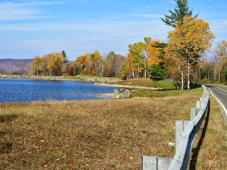
| The Westfield River is officially designated a Wild and Scenic River |
At its end I turned back west on Rt. 9, aiming for Worthington Road, which I haven't ridden in this direction, then followed it south to Rt. 143. It is another fun little Berkshire road, this one passing next to protected parkland.
 |
| Color remains in the trees on Worthington Road |
Then Rt. 143 west to another River Road, this one familiar and almost all downhill. The road stays close to the river, and until reaching Huntington the surface is good. From there it was frequently bone-jarringly bad. Cracked, full of holes, years and years of bad fixes, and now loose gravel added to the mix. Not fun. Too rough to watch the river, too rough to ride fast.
 |
| That horse at the top of River Road in Worthington was curious about my bike |
This was followed by the only sustained climb, up to Chester ... 1.25 miles, 530 feet. I don't know how to do the arithmetic on that, but it was long and never too steep, though there was no respite along the way.
Skyline trail is always a pretty ride, and it didn't disappoint. The woods, by the way, are full of sparrows, along with a few warblers and thrushes. It must be just about the end of migration for most of them.
 |
| The view west from Skyline Trail |
All in all, a great way to spend the day getting a cup of java. 58.91 miles, 4543 feet climbing.
The map:
View Savoy Loop in a larger map
Quite a good ride for a single cup of coffee. Do the trees keep you protected from the wind?
ReplyDeleteYes! The trees do a good job of keeping the wind away. I h a t e wind. It's not related to the bike, I don't even like to listen to it from indoors. Ah, what I'll do for a cuppa;-)
ReplyDeleteI enjoy learning new interesting roads in the area. Although I live in NW CT, I ride in the GB area a lot for the same reason-interesting roads, light traffic and what traffic I do encounter is very bike-friendly.
ReplyDeleteThanks
Hi z-man,
ReplyDeleteFirst, thanks for taking the time to comment... I love to hear from readers, and wish more people would chime in!
Yes, there are great little winding roads in southern Berkshire county, I ride there frequently also. I've been told that traffic there is more bike friendly than further north, but haven't experienced that myself.
How are the roads in northwestern CT? It is just far enough away that I almost never get there, but often think I might.