12 miles Dirt roads
Chesterfield
Trustees of Reservations parking lot
Chesterfield
Trustees of Reservations parking lot
Chesterfield Gorge is a Trustees of Reservation Property that abuts State Forest land. It is spectacular.
 The Trustees of Reservations, www.thetrustees.org, is a private not-for profit organization, the oldest “statewide land conservation and historic preservation organization in the country.” They protect 37,000 acres in Massachusetts and own many beautiful sites in the Berkshires.
The sun was out, the weather warm, considering that it was the second week in November, and my bike was in the back of the car. So I stopped on my way back from Northampton, to ride River Road, a mountain bike route that goes from Chesterfield Gorge into Gilbert Bliss State Forest along the west bank of the river.
I followed it south for about 6 miles. So far as I know, this is a one-way ride; in any case, I returned over the same route. For me, this is a better walk than ride. Because of the frequently rough dirt surface, I spent more time looking at the ground in front of me than looking at the river.
Sometimes the surface was well packed and easy riding, sometimes it was rougher and stonier. A mountain biker would always have been very comfortable; the trail wasn’t difficult. I would have preferred my Trek, especially with somewhat knobby tires on it, though my touring bike’s tires were fine.
Photos, not words for this post. The ride was short, the sun going down, the temperature warm.
The gorge near the parking lot, with 70-foot steep walls, created by the East Branch of the Westfield River.
Huge glacier erratic at the side of the road. There are a number of them, many larger and more cliff-like than this one. They must make excellent bobcat habitat.

The river flattens out quickly.
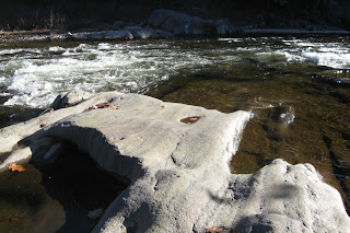
River rocks have been worn smooth by millennia of passing waters.
Human presence shown by a hand-built stone retaining wall, with a passage in the wall to let floodwaters through. This might be the remains of a bridge dating from 1762. The river is immediately out of sight on the left.
The gorge opened up towards the south end of my ride to a wide floodplain.

A fly fishermen in the river. It is a catch-and-release river that has National Wild and Scenic River status.


No comments:
Post a Comment
My blog is out of date, and so comments are closed.
Note: Only a member of this blog may post a comment.